


1. 서 론
동해 남부 해역은 대한해협을 통해 유입되는 대마난류가 두 갈래로 나눠진다. 하나는 일본 연안을 따라 북동쪽으로 흐르는 일본 연안 분지류, 또 다른 하나는 한국 연안을 따라 북상하는 동한난류이다(Suda and Hidaka, 1932; Uda, 1934; Kawabe, 1982; Kim et al., 2020).
특히, 동해 울릉도 및 독도 해역은 동한난류와 북한한류가 교차함에 따라 북상하던 동한난류가 한국 연안으로부터 이안되어 사행하며(Hyun et al., 2009; Kim et al., 2014; Baek and Kim, 2018), 이 사행으로부터 첫 번째 마루에서 시계방향으로 회전하는 울릉 난수성 소용돌이(An et al., 1994; Lee and Niiler, 2010; Shin et al., 2005)와 독도 주변으로 동한 난류 사행의 첫 번째 골에서 반시계 방향으로 회전하는 독도 냉수성 소용돌이(Mitchell et al., 2005b; Kim et al., 2019)가 발생한다. 울릉도-독도 해역의 난수성/냉수성 소용돌이의 발생은 해류와는 다르게 열, 염, 운동량, 그리고 영양분 등 물질을 운반하고 혼합하며 에너지를 전달하여 대양에서의 순환과 해양 생태계 유지에 중요한 역할을 한다. 해양의 소용돌 이를 탐지하는 것이 해양학적으로 매우 중요한 일이 때문에 소용돌이를 탐색하고, 소용돌이 구조와 이동에 관한 분석이 과거부터 현재까지 지속적으로 이루어져왔다(Wyrtki et al., 1976; Kang and Kang, 1990; Morimoto et al., 2000; Gordon et al., 2002; Lee and Niiler, 2005; Mitchell et al., 2005a; Shin et al., 2019).
이처럼 동해 남부 해역은 매우 다양한 해양 현상들이 복합적으로 작용하는 곳으로, 이 해역의 자세한 해양구조를 정확하게 이해하고 재현하는 것은 매우 중요하다. 그러나 현재 관측하고 있는 자료로는 난수성/냉수성 소용돌이의 탐지 및 해양순환, 그로 인한 물리구조의 변화 등을 이해하고 재현하기에는 한계가 있다. 이러한 한계를 극복하고자 해양순환 수치 모델을 도입하게 되었고, 수치모델연구는 지속적으로 개발되어 운영되고 있다(Kim et al., 2013). 국내 여러 기관에서도 동해의 해양순환을 목적으로 다양한 수치모델이 지속적으로 개발되고 있다. 그러나 수치 모델을 구성하는 기본 방정식들의 가정과 근사로 인하여 실제 해양 현상을 완벽하게 표현하지 못하고 해양 현상의 비선형성과 관계된 초기장에 대한 민감한 의존성을 가지기 때문에 해양 상태의 정확한 재현 및 예측에는 근본적인 한계를 가지고 있다(Chang, 2015).
울릉도와 독도는 생태, 환경적 가치가 높을 뿐만 아니라 열, 염, 영양분 등의 물질이 활발하게 혼합되는 해역이기 때문에 회유성 어종이 풍부하고, 해양 동물과 해조류 등이 풍성하여 수산자원으로서의 가치도 높은 해역이다(Chang et al., 2002). 또한, 2019년 10월 독도 인근해상의 헬기 추락사고 등으로 인해 울릉도, 독도 해역에서 발생하는 해상 재난 사고에 능동적으로 대응해야 할 필요성이 증대되고 있다.
본 연구에서는 울릉도와 독도해역의 표층 해수 유동을 예측하기 위하여, 첫 번째로는 수평 해상도를 3 km(수평 해상도 1/36°)에서 1 km(1/108°), 그리고 300 m(1/324°)까지 단방향 둥지격자기법에 적용하여 고해상도화하여 해양재분석자료에 따른 울릉도와 독도 주변 해역의 해수 순환을 모의하였다. 두 번째로는 모의된 순환을 분석하여 CMEMS(Copernicus Marine and Environment Monitoring Service, http://marine.copernicus.eu) 해류 자료와 국립수산과학원 정선관측자료의 CTD(Conductivity-Temperature-Depth) 자료를 이용하여 비교·검증을 하였다. 마지막으로는 수치모델 결과를 근거로 울릉도-독도 고해상도 모델의 개선방향에 대해서 논의해보고자 한다.
2. 자료 및 검증 방법
2.1 해양순환 수치모델
울릉도-독도의 물성과 해수순환을 재현하기 위해 본 연구에 사용한 해양수치모델은 Regional Ocean Modeling System (ROMS; Song and Haidvogel, 1994)을 사용하였다. ROMS는 나비에-스토크스(Navier-Stokes) 방정식에 정역학 근사와 부시네스크(Boussinesq) 근사를 적용한 원시방정식, 그리고 수온·염분 등에 대한 상태방정식을 사용하는 전형적인 3차원 해양순환모델이다(Shchepetkin and McWilliams, 2005). 수평격자 체계는 격자 중심에 밀도, 수심, 수온을, 격자의 좌우에 유속의 동서 성분(u), 상하에 남북 성분(v)을 주어 계산의 안정성과 효율성을 높인 Arakawa-C의 아격자체계를 사용하며(Arakawa and Lamb, 1977), 수직 격자는 S-좌표계(Stretched terrain-following coordinate)를 사용한다(Song and Wright, 1998; Shchepetkin and McWilliams, 2005). 이 좌표계는 z-좌표계의 PBL(planetary boundary layer) 장점과 σ-좌표계의 바닥 경계층 구현의 장점을 살린 좌표계로 수직적으로 조밀하게 수심 간격을 설정할 수 있다. 또한 대기와 해양순환간의 상호작용을 표현할 수 있도록 Bulk Parameterization(Fairall et al., 1996) 기법을 적용하였다.
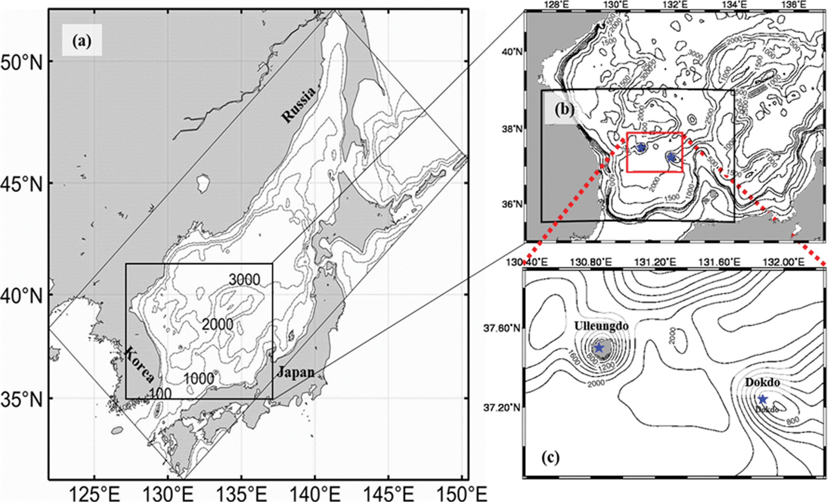
본 연구에서는 전지구 해양재분석자료인 HYCOM(HYbrid Coordinate Ocean Model/Navy Coupled Ocean Data Assimilation) 자료와 동해 3 km 수치모델(이하 ES3K)를 각각 최상위 둥지격자(mother grid)로 선정하였다. 이를 울릉도 1 km 수치모델(이하 UD1K)에 초기장 및 경계조건으로 단방향 둥지격자기법을 적용하여 수치실험을 수행하였다. 이 UD1K 수치모델 결과를 다시 경계조건으로 단방향 둥지격자 기법을 적용하여 울릉도-독도 초고해상도(이하 UD300m) 해양순환모의를 수행하였다. Fig. 1은 본 연구를 위해 구축한 3개의 수치실험 영역이다. ES3K 영역에서는 대한해협과 쓰가루 해협, 소야 해협, 타타르해협, 울릉도, 독도를 모두 포함하는 해역으로 동해 전체 해역에서 발생하는 해수순환을 모의하고자 하였다(Fig. 1a). UD1K 영역에서는 동해 남부와 중부 지역을 포함하는 해역으로 동한난류의 흐름과 사행, 울릉도와 독도 인근에서 발생하는 난수성/냉수성 소용돌이 등 다양한 순환을 모의하고자 하였다(Fig. 1b). UD300m 영역에서는 울릉도와 독도만을 포함하는 해역으로 울릉도와 독도 인근의 해수 순환과 난수성/냉수성 소용돌이 순환 등을 모의하고자 하였다(Fig. 1c).
본 연구에서 수행한 동해 3 km 모델(ES3K)과 울릉도 1 km 모델(UD1K), 울릉도 300 m 모델(UD300m)들의 대기강제력은 수평 해상도가 약 25 km(1/4°)인 ERA5 1시간 자료를 내삽하여 사용하였으며, 연직층은 41개층이다. 동해 3 km 모델의 수심자료는 한국해양과학기술원(Korea Inaptitude of Ocean Science & Technology, KIOST)에서 제공하는 KorBathy30s (Seo, 2008)와 NGDC(National Geophysical Data Center)에서 제공하는 수평해상도가 1/12°인 ETOPO5 자료이며, 울릉도 1 km 모델과 울릉도 300 m 모델의 수심자료는 상위모델의 수심자료를 이용하였으며, 동해 해안선과 울릉도·독도를 자세하게 표현하기 위해 KorBathy30s를 사용하였다(Table 1). 초기장 및 개방 경계 자료로는 HYCOM에서 제공하는 유속, 수온, 염분, 해수면 높이의 일평균 자료를 기반으로 사용하였다. 그리고 울릉도-독도 300 m 수치모델을 정확하게 구축하기 위해, 단반향 둥지격자기법을 2가지로 구분하여 수행하였다. 첫 번째로는 HYCOM(수평 해상도 약 9 km)-ES3K(약 3 km)-UD1K(약 1 km)-UD300m(약 300 m) 순으로 순차적으로 단방향 둥지격자 기법을 이용하였다. 두 번째 방법은 동해 3 km 수치모델을 제외하고 HYCOM(수평 해상도 약 9 km)- UD1K(약 1 km)-UD300m(약 300 m) 순으로 진행하였다. 두 가지 단방향 둥기격자 기법 중, 첫 번째 방법은 ES3K 수치모델 결과를 사용한 기법으로 UD1K와 UD300m 실험은 각각 ES_UD1K, ES_UD300m 라 정의하였으며, ES3K 실험의 결과를 제외한 두 번째 방법은 HY_UD1K, HY_UD300m라 정의하였다. 수직 난류 점성 및 확산계수를 결정하는 수직혼합기법에는 K-Profile Parameterization scheme(KPP; Large et al., 1994)를 적용하였다.
본 연구에서 구축하는 수치모델은 수평 해상도가 최대 3 km에서 최소 300 m까지 고해상도 모델이다. 따라서 동해 전체 순환을 잘 모의하기 위해서는 동해에 주요 강물 유입(freshwater flux)울 고려할 필요가 있다. Nof(2001)은 동해에 공급되는 담수의 감소는 동해 북부에서 저층수(bottom water) 형성을 야기한다고 하였다. 이 저층수 형성으로 인해 대한해협 주변 상층 두께가 얇아지면서 동한난류 북상에도 영향을 준다(Cho and Kim, 1996; Kim et al., 2020). 또한 강물 유입으로 인해 상층 염분과 밀도 변동이 나타나며, 이는 지역적으로 해수 밀도 차가 나타나면서 밀도류(density-driven current)가 나타나게 된다. Yoon(1982)는 수치모델 실험을 통해 실제 동해 상층 해류는 밀도 차에 의해 동해 주요 해류 특징인 일본연안분지류(Nearshore branch)를 재현하였다. 따라서 3 km 수치모델(ES3K) 개방 경계 자료에만 추가적으로 RIVDIS(Global River Discharge Data; http://globec.whoi.edu/IGBP/RivDIS_database/html)에서 제공하는 월평균 자료의 낙동강, 두만강, 아무르 강의 강물 방류량 자료를 적용하였다. 그리고 동해는 서해와 남해보다 조석에 의한 조류의 영향은 미약하다. 그러나 동해를 포함하여 수치실험을 한 이전 많은 연구(Kim et al., 2015; Lee et al., 2016; Choi et al., 2018)에서는 조석의 영향이 큰 4대 분조(M2, S2, O1, K1)를 포함하는 8개 분조 또는 10개 분조를 적용하였다. 따라서 본 연구에서도 Oregon global model version 6(TPXO6)의 10개 분조(M2, S2, O1, K1, N2, K2, P1, Q1, Mf, Mm)의 조석자료(수평 해상도가 0.25°)를 수치 모델의 격자에 맞게 내삽하였다. 이 조석자료는 TOPEX/Poseidon 인공위성 관측 자료를 이용한 전 지구 모델(Oregon global model)의 결과이다(Egbert and Erofeeva, 2002). 혼합계수는 각각 20 m2/s, 1 m2/s, 1 m2/s, 점성계수는 20 m2/s, 1 m2/s, 1 m2/s로 적용하였다(Table 1).
2.2 검증자료 및 방법
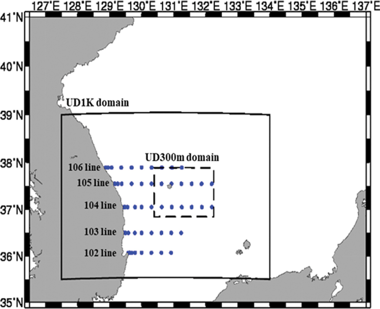
본 연구에서 해양순환모델의 검증을 위해서, 2018년 1월 1일~12월 31일(1년)의 위성관측자료(CMEMS)와 국립수산과학원에서 선박을 이용하여 2달에 한번 씩 관측하는 102~106 라인의 정선관측자료(National Institute of Fisheries Science, NIFS)를 사용하였다(Fig. 2). 인공위성 고도계 관측자료(CMEMS)는 여러 인공위성(Jason-1, Jason-2, Jason-3, Sentinel-3A, HY-2A, Saral/AltiKa, Cryosat-2, T/P, ENVISAT, GFO, ERS1/2)의 궤적(along-track)의 지상궤적(along-track) 관측한 자료들을 병합하여 일정한 수평 격자 간격(0.25° × 0.25°)으로 최적합보간(Optimal Interpolation)하여 일평균 자료를 제공한다.
해상도에 따른 정확도 향상을 분석하기 위하여 HYCOM, ES3K, UD1K, UD300m 모델 결과를 동일한 영역(UD300m 실험 영역)에서 관측자료(CMEMS, NIFS)와 모델 자료간의 Mean Bias(Mbias), Root Mean Square Error(RMSE), Pattern Correlation(PCorr.), Vector Correlation(VCorr.)을 도입하여 검증하였다. Vector Correlation은 유속 벡터(u, v) 성분을 나누지 않고, 하나의 벡터 집합체에 관해 평가하기 위해서 사용한다(Stephens, 1979). 이 Vector Correlation은 공분산행렬을 구성하여 계산하기 때문에 하나의 상관계수로 산출되어 평가할 수 있다는 장점이 있다. Vector Correlation은 0~2의 값을 가지며, 그 값이 클수록 상관성이 높다는 것을 의미한다. 각각의 수식은 다음과 같다.
2.3 해양순환 수치모델의 개방 경계장 산출시 유의사항
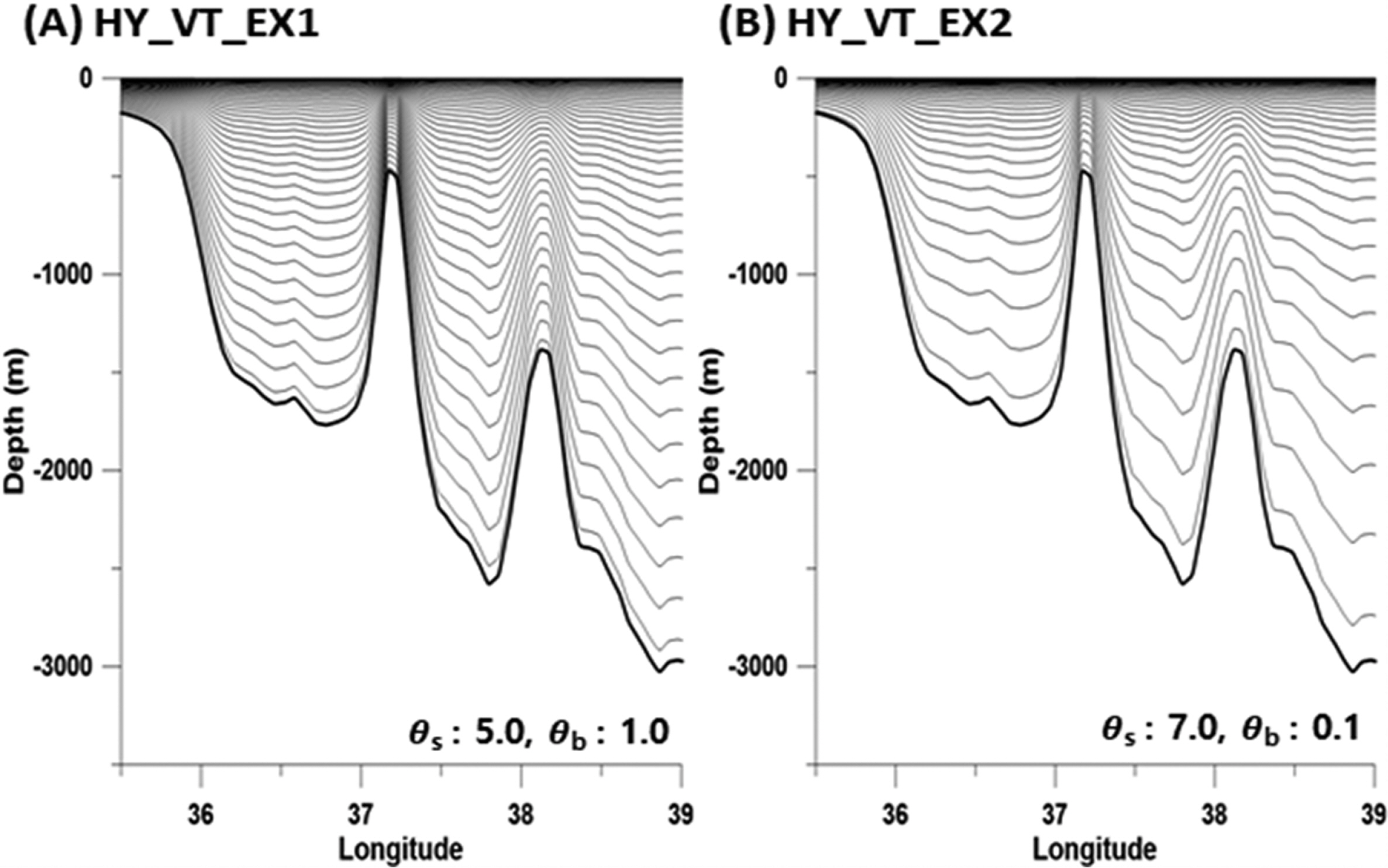
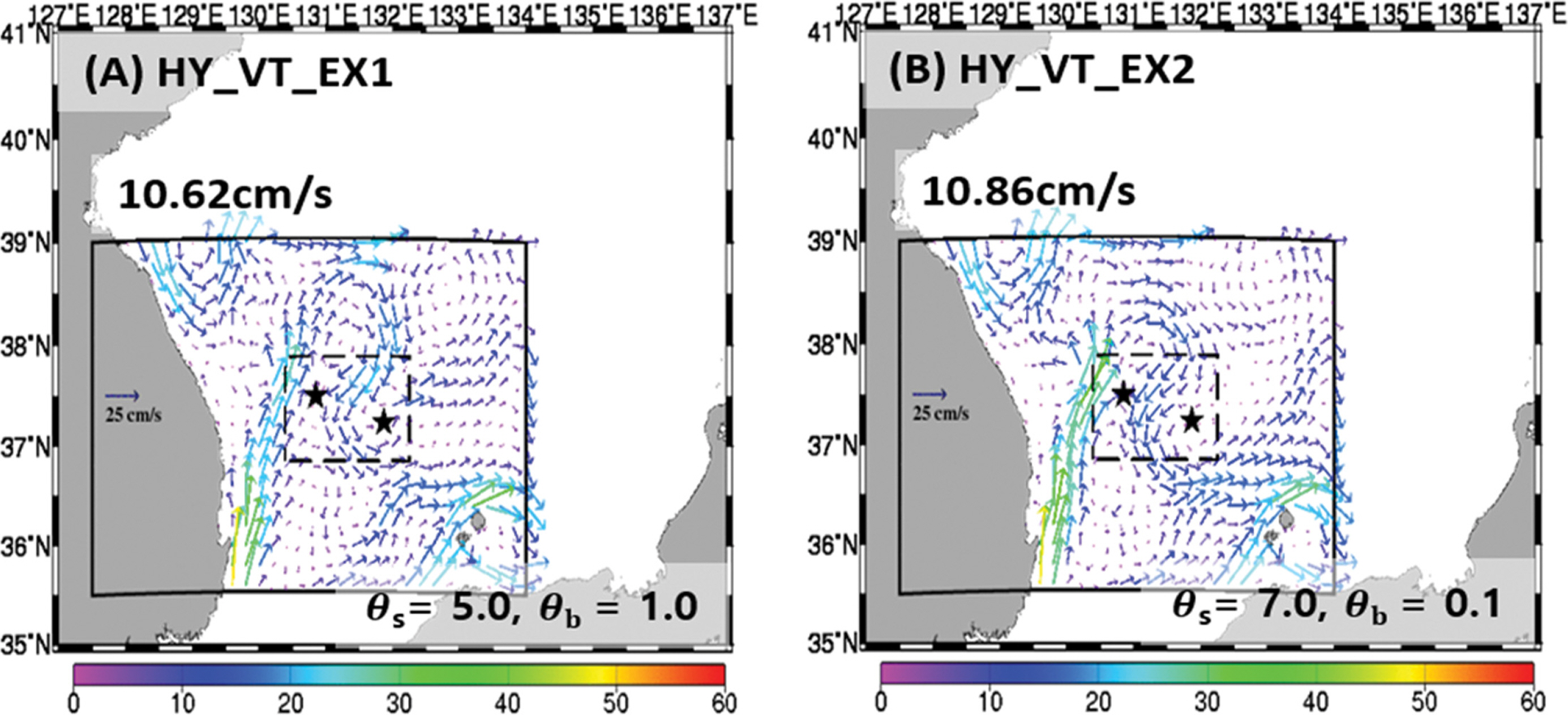
해양 순환 수치모델을 구동하기 위해서는 실험 영역의 해역 특성을 고려하여 초기장 및 경계장 자료를 왜곡 없이 생성할 필요가 있다. 본 연구에서 사용한 ROMS 모델은 앞서 언급한 것과 같이 수직 좌표는 S-좌표계이기 때문에, 수직 격자 간격에 따라 동해의 급격하게 변하는 수심 지형에 민감하게 반응하는 압력구배의 오차가 나타날 수 있다. 이를 최소화하기 위해, ROMS 모델은 Shchepetkin and McWilliams (2009)에 의해 제안된 수직 확장 함수에서 θs와 θb를 이용하여 수직 간격을 조절할 수 있다. 본 연구에서는 적정한 수직 간격을 선정하기 위해 울릉도 1 km 수치모델을 기준으로 민감도 실험을 수행하였다. 먼저 HY_VT_EX1은 하층 수심 간격을 조밀하게 나타내기 위해 θs와 θb를 각각 5.0, 1.0으로 설정하였으며, HY_VT_EX2는 반대로 상층 수심 간격을 조밀하게 나타내기 위해 θs와 θb를 각각 7.0, 0.1로 설정하였다(Fig. 3). Fig. 4는 각 수직 확장 함수에 따른 2018년 울릉도 1 km 수치모델의 표층 연평균 분포를 나타낸 것이다. 전체적으로 울릉도 1 km 수치모델의 실험 영역에서 연평균 표층 해류는 한국연안을 따라 북상하는 동한난류가 37.0° N 이북에서 이안되어 사행한다. 두 실험은 유사한 표층 해류분포를 나타내지만, 상층 수심이 조밀한 HY_VT_EX2인 경우 HY_VT_EX1에 비해 관측자료(CMEMS)와는 남북 성분(v)의 RMSE는 약 6.97 cm/s로 EX1에 비해 약 0.70 cm/s 낮게 나타난다(Table 2). 그리고 VCorr.은 EX2(약 0.72)가 EX1(약 0.59)에 비해 약 0.13 높게 나타난다. 따라서 본 연구에서는 관측자료와 비교하였을 때, 더 정확성이 높게 재현하는 HY_VT_EX2의 수직 확장 함수(θs: 0.7, θb: 0.1)를 선택하였다.
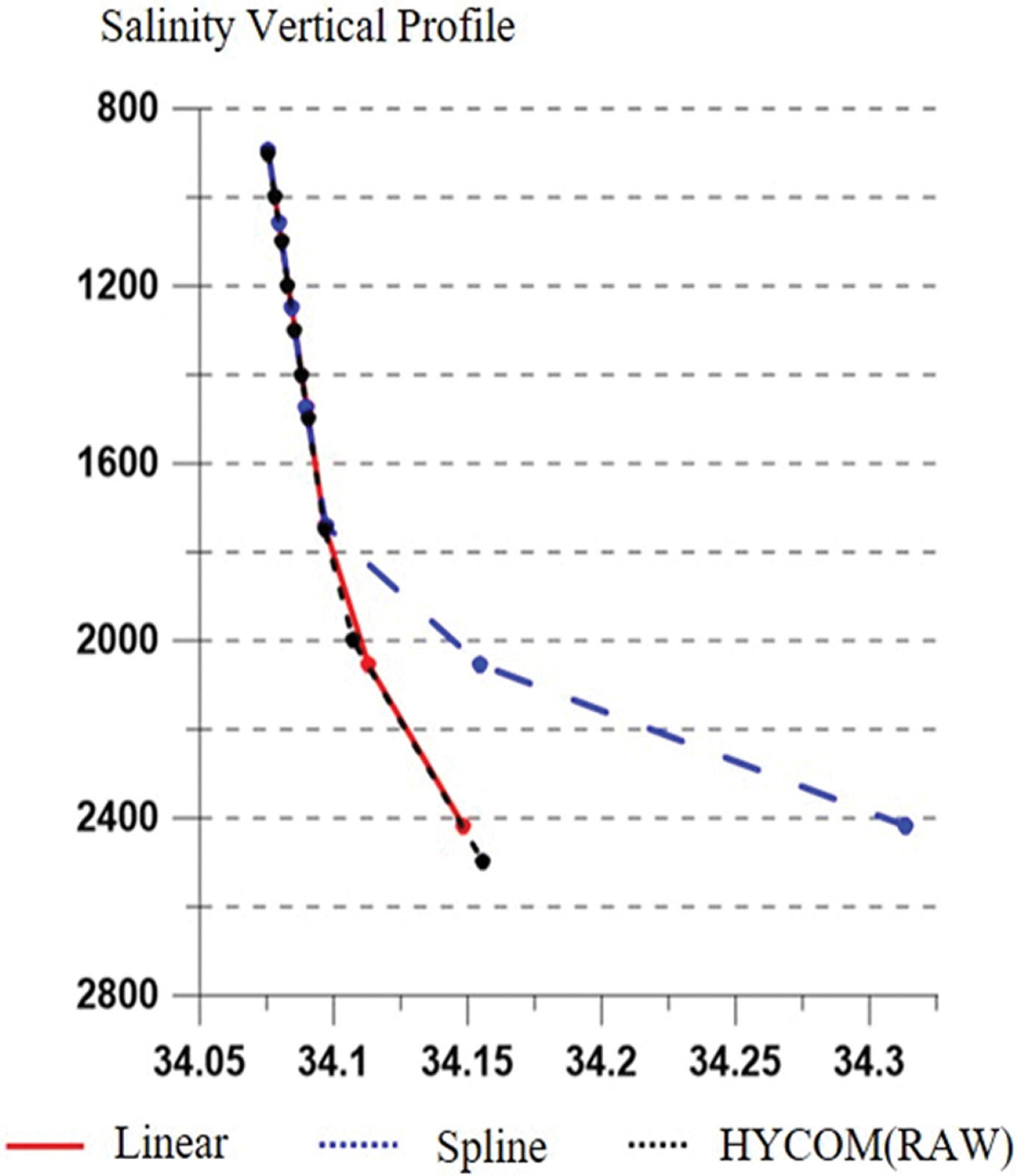
두 번째로 고려할 사항은 단방향 둥지격자기법에서 경계조건에 입력되는 모델의 결과와 둥지격자기법을 적용하는 고해상도 모델의 경계지역의 결과가 수심에 따라 자료의 왜곡이 없어야 한다는 점이다. 따라서 경계조건의 자료들이 왜곡 없이 적용될 수 있도록 내삽기법을 비교하였다(Fig. 5). 연직 내삽에 주로 사용되는 기법인 Spline 내삽기법과 Linear 내삽기법에 대해서 수심에 따른 염분 자료의 차이를 비교하였다. 우선 해양재분석자료에서 제공하는 자료보다 모델에 적용되는 수심 자료가 보다 깊은 수심까지 자료가 필요할 수 있다. 이때 수직적 내·외삽 방법으로는 Spline 방법을 적용을 한다면(Fig. 5에서 blue line), Linear 방법(Fig. 5에서 red line)과는 다르게 크게 왜곡이 될 수 있다. Spline 방법은 각 차원의 인접한 격자점에서 3차 다항식 함수를 이용하여 내·외삽하기 때문에 최소 4개의 자료가 필요하다. 예를 들어 수심 2000 m 보다 깊은 수심에 최소 2개의 자료가 없다면, 경계자료는 왜곡되어 다른 값이 생성된다. 반면에 Linear 방법은 인접한 격자점 개수와 상관없이 상위모델의 결과와 유사하게 재현된다. 따라서 경계조건을 내·외삽 할 때에는 Linear 기법을 사용하였다.
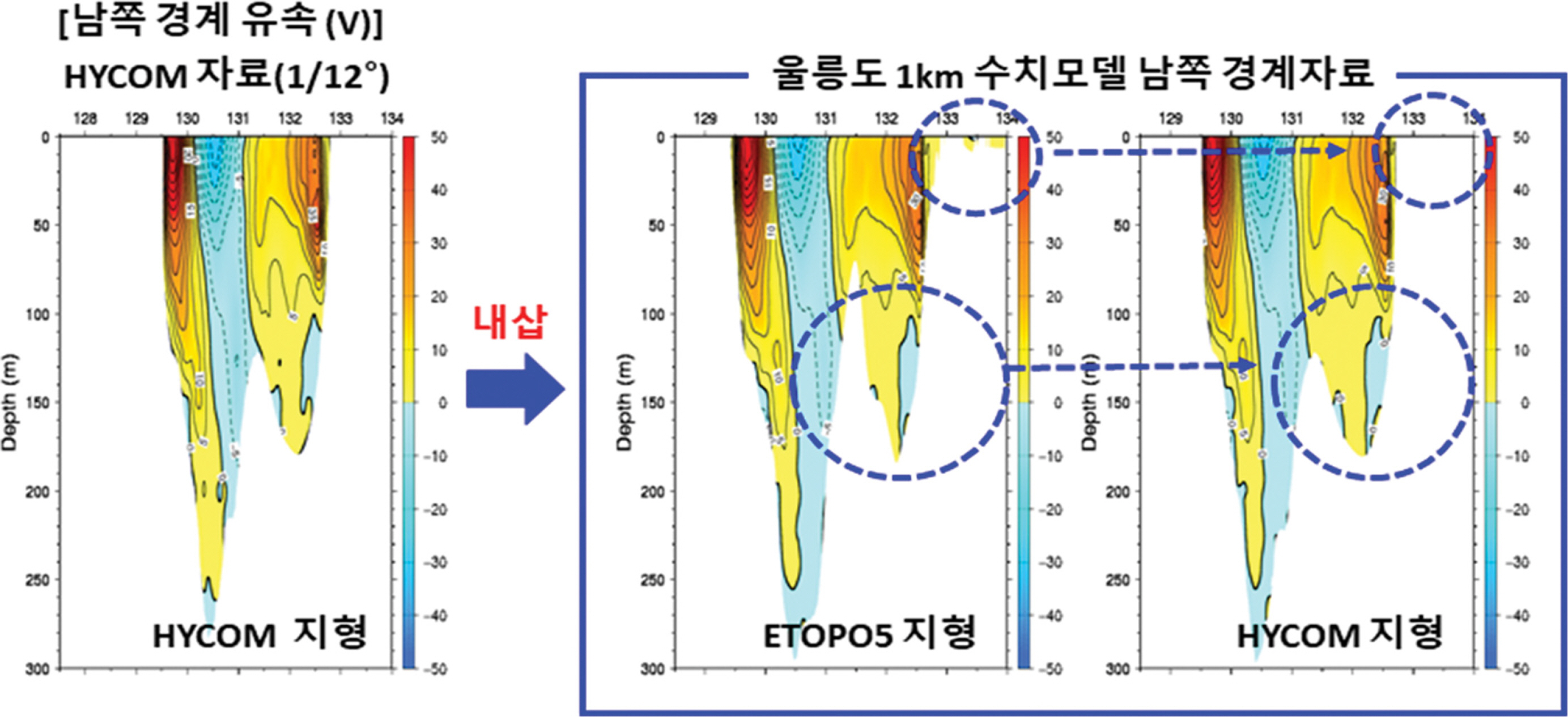
마지막으로는 본 연구에서 울릉도 1 km 수치모델의 초기장 및 경계장 자료로 사용하는 HYCOM 자료와 동해 3 km 수치모델의 수심자료가 서로 다르기 때문에, 각 격자점마다 수심 및 연안 지형이 다르게 나타난다. 만약 HYCOM 자료를 경계장으로 사용할 때 ETOPO5 수심자료를 적용하여 울릉도 1 km 수치모델 경계자료를 산출한다면, 경계장 자료는 수평 또는 수직적으로 HYCOM 자료와는 다른 자료 값들이 내·외삽이 되어 모델에 적용될 수 있다. Fig. 6은 HYCOM 자료와, ETOPO5와 HYCOM에서 제공하는 수심자료를 각각 이용하여 울릉도 1 km 수치모델의 남쪽 경계(35.5° N)에서 8월 남북 성분(v)의 수직단면도이다. HYCOM의 수심자료는 132.7~134.0°E까지 육지이지만, ETOPO5 지형은 수심 10 m 이하의 얕은 바다가 나타난다. 또한 131.5°E 부근에서는 ETOPO5 지형이 HYCOM에서 사용한 지형보다 더 깊게 나타난다. 이로 인해 남쪽 경계에서 실험 영역으로 유입되는 수송량 또는 자료 왜곡에 의한 차이가 나타날 수 있다. 따라서 본 연구에서는 울릉도 1 km 수치모델의 초기장 및 경계장을 생성 시 상위모델의 수심자료를 적용하였다.
3. 연구 결과
3.1 연평균 표층유속 특성비교
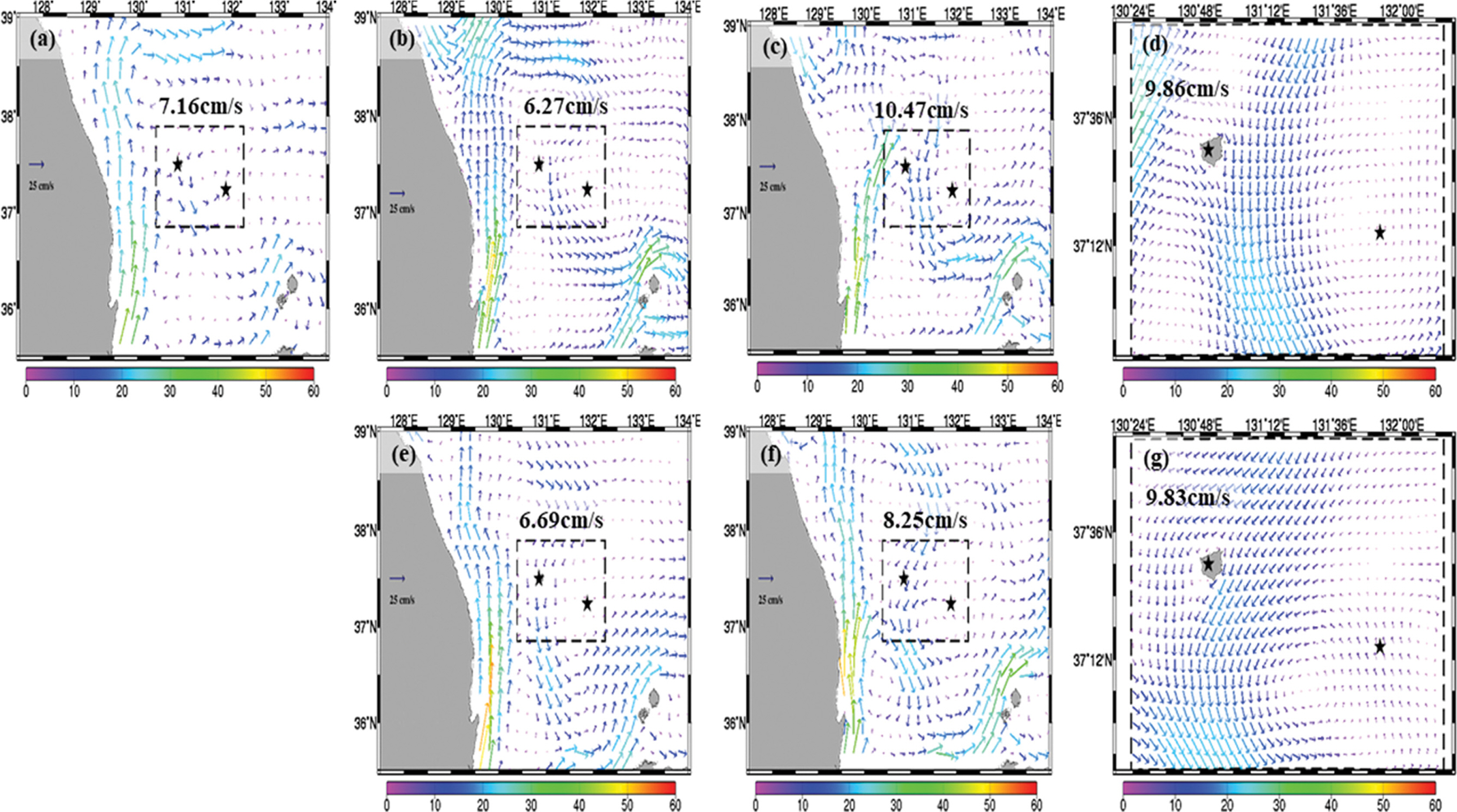
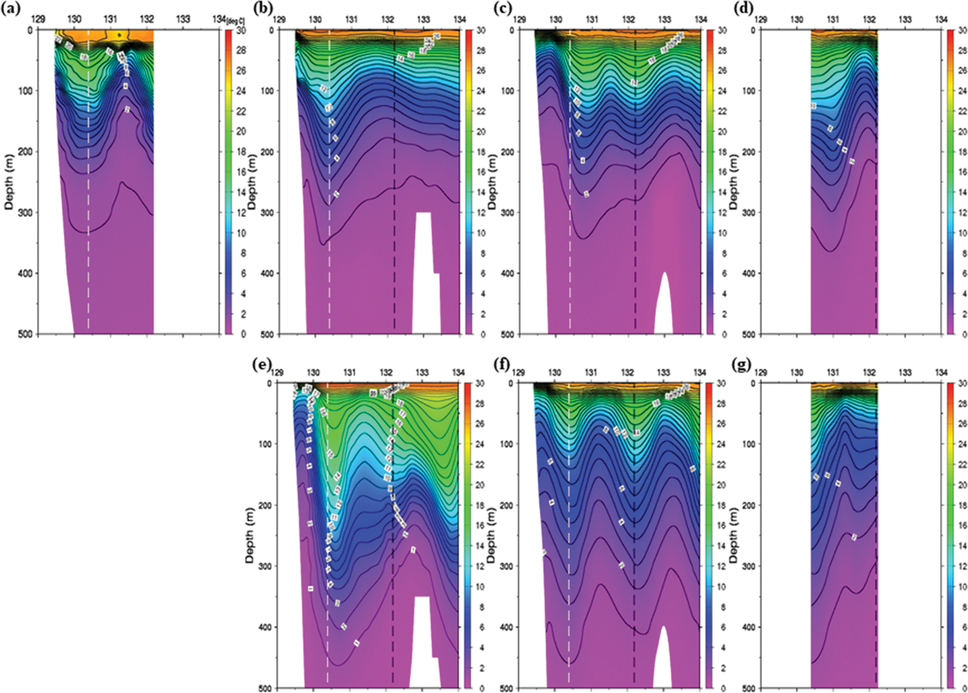
본 연구에서 실험한 표층유속 모의결과의 연평균 자료를 CMEMS자료와 비교하였다(Fig. 7). 울릉도-독도 300 m 해역에서의 평균 유속은 약 7.16 cm/s로 나타났다(Fig. 7a). HYCOM에서는 약 6.27 cm/s, ES3K에서는 약 6.69 cm/s로 CMEMS 보다 작게 나타났으나(Fig. 7b, 7e), 울릉도 1 km 수치모델(UD1K)에서는 HYCOM을 사용한 수치모델 실험에서는 약 10.47 cm/s, ES3k를 사용한 실험에서는 약 8.25 cm/s로 평균 유속이 급격하게 증가하였다(Fig. 7c, 7f). 또한, HY_UD1K에서는 동한난류가 울릉도 해역으로 유입되며, 연평균 표층 해류가 기존 HYCOM 보다 강하게 나타났다. HY_UD300m의 평균해류(Fig. 7d, 7g)는 약 9.86 cm/s, ES3k_UD300m의 평균해류는 약 9.83 cm/s로 각 UD1K의 평균해류와 거의 유사하게 나타난다. 그러나 HY_UD300m는 울릉도 서쪽 해안을 따라 북상하는 흐름이, ES_UD300m는 남하하는 흐름이 나타난다. 이는 같은 연구 영역일지라도, UD300m 고해상도 수치모델의 결과는 상위모델에 의해 크게 변형되는 것을 확인할 수 있었다.
Table 3은 위성 관측자료 CMEMS 2018년 연평균 유속 벡터(u, v) 성분에 대한 HYCOM, HY_UD1K, HY_UD300m, ES3K, ES_UD1K, ES_UD300m 간의 Mbias, RMSE, PCorr., VCorr. 검증결과이다. 유속벡터의 동서 성분(u)의 RMSE는 HYCOM이, 남북 성분(v)의 RMSE는 ES3K가 각각 4.03, 2.55로 가장 낮게 산출되었다. ES_UM300m의 결과가 동서 성분(u)과 남북 성분(v)의 RMSE 모두 각각 약 6.32, 6.11로 가장 높게 산출되었다. 동서 성분(u)의 Mbias는 HYCOM과 HY_UD1K가 각각 -0.03. 0.09로 가장 좋은 결과를 보였고, ES_UD300m의 결과가 약 -5.36, -2.95로 가장 높게 산출되었다. Pattern Correlation(PCorr.) 결과는 모든 수치모델 실험(ES3K, UD1K, UD300m)에서 모두 99% 신뢰수준(PCorr. = 0.418)에서 통계적으로 유의성을 가지는 것을 알 수 있다. 특히, ES_UD300m의 동서 성분(u)이 0.80, ES3K에서는 남북 성분(v)이 0.66으로 가장 높게 산출되었다. HY_UD1K의 동서 성분(0.59)과 ES_UD300의 남북 성분(0.45)에서 가장 낮은 결과를 보였다. VCorr.은 ES3K가 가장 우수한 1.03의 결과를 보였고, ES_UD1K가 가장 낮은 0.84로 확인되었다. 1 km와 300 m의 차이를 확인해 보면 HY_UD1K보다 HY_UD300m 유속 성분(u, v)의 RMSE는 근소하게 향상되었고, PCorr.은 동서 성분(u)이 0.08, 남북성분(v)이 0.06 향상되었다. VCorr.은 0.89에서 0.91로 약 0.02 향상되었다. ES_UD1K보다 ES_UD300m가 동서 성분(u)의 PCorr.은 약 0.12 정도 향상되었으나, 나머지 검증 스코어에 대해서는 크게 향상되는 결과가 나타나지 않았다.
3.2 2월 평균 표층유속 비교
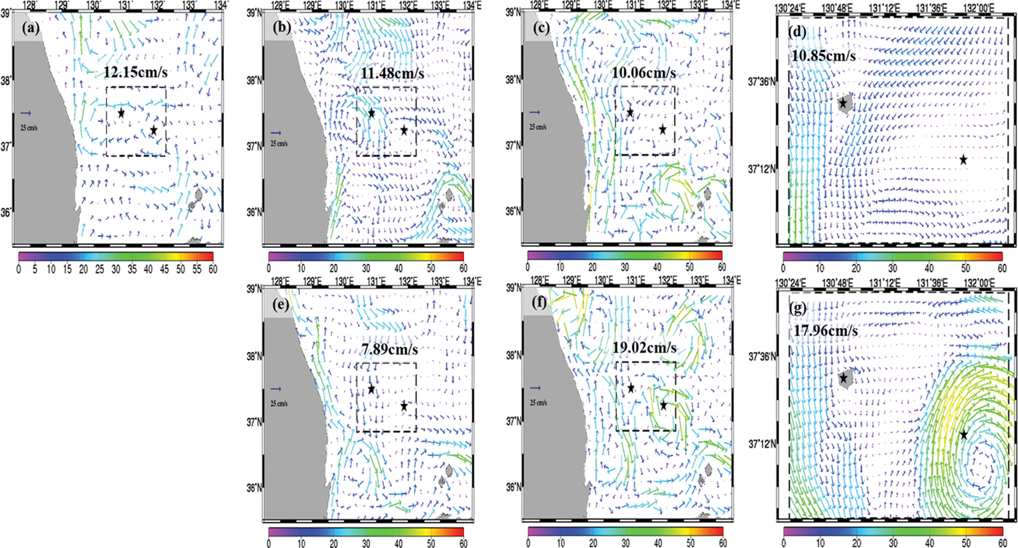
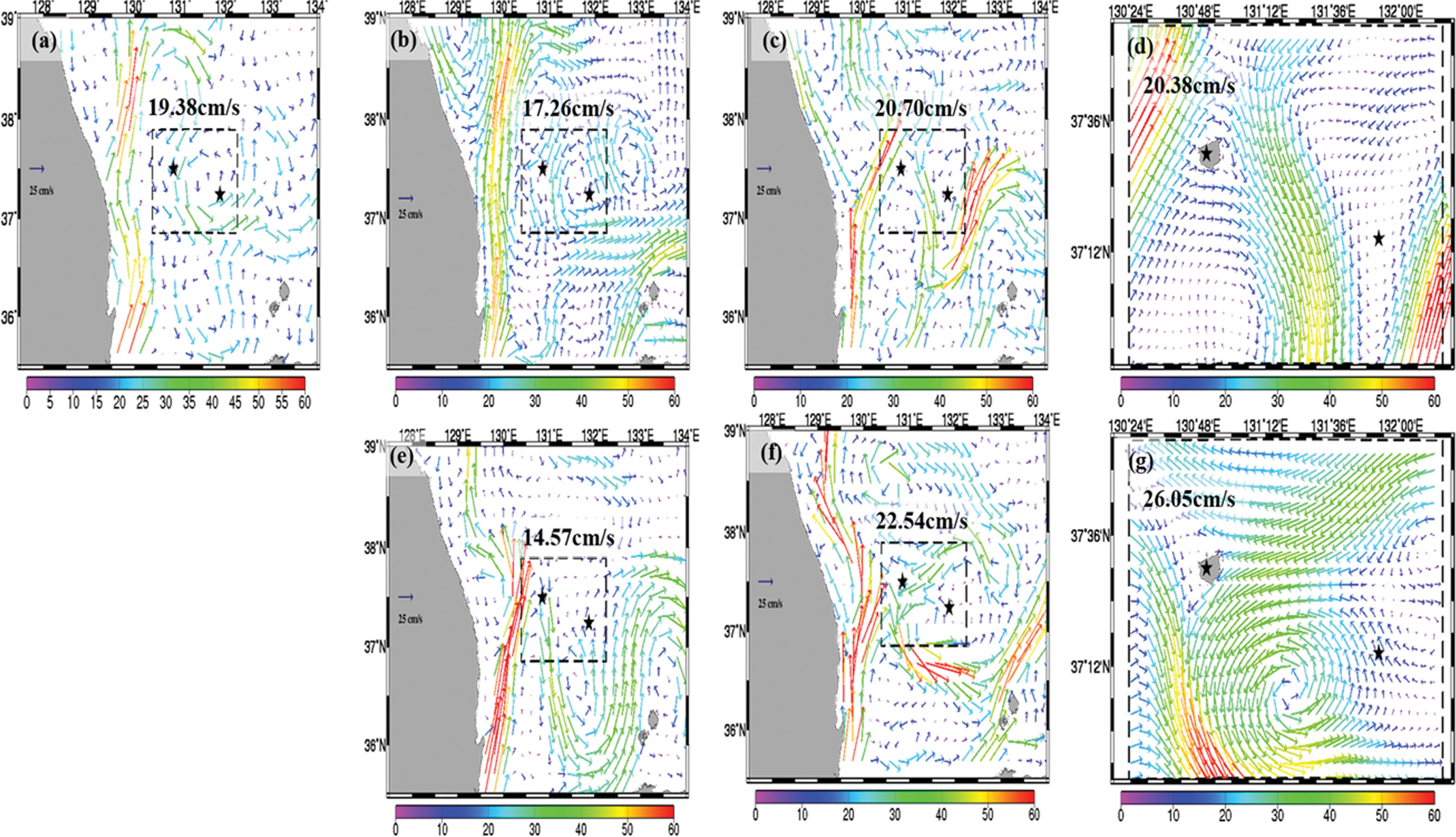
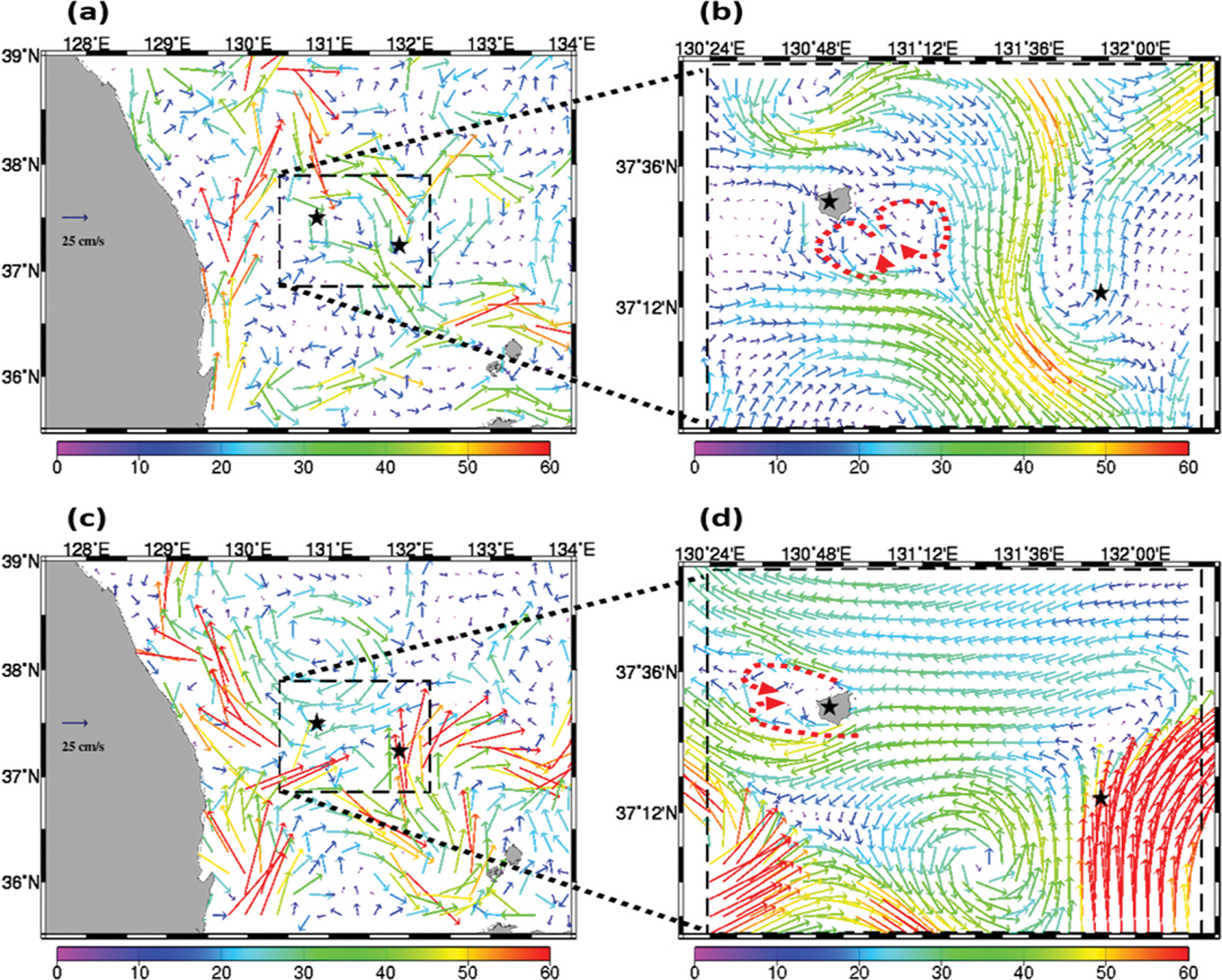
Fig. 8은 CMEMS와 HYCOM, HY_UD1K, HY_UD300m, ES3K, ES3K_UD1K, ES3K_UD300m의 2월 평균 표층유속을 비교한 내용이다. 울릉도-독도해역에서의 CMEMS에서 관측된 평균 유속은 12.15 cm/s이고, 울릉도 북부에는 동쪽으로 흐르는 유동이 나타나며, 독도 인근에서는 시계방향으로 회전하는 소용돌이가 존재하는 것을 확인할 수 있었다. HYCOM 재분석자료는 평균 11.48 cm/s로 큰 차이가 나타나지는 않았지만, 울릉도 부근에서 남쪽으로 흐르는 유속이 강하게 나타났고, 독도 인근에서의 소용돌이는 보이지 않았다(Fig. 8b). HY_UD1K와 HY_UD300m는 각각 10.06 cm/s, 10.85 cm/s로 CMEMS의 평균 유속과 크게 차이나지는 않았으나, HYCOM 둥지격자기법의 영향으로 남하하는 흐름을 과대 모의하는 양상을 확인할 수 있었다(Fig. 8c, d). ES3K 모델도 HYCOM과 유사하게 울릉도 부근에서 남하하는 흐름을 주로 모의하고 있으며, 평균유속은 약 7.89 cm/s로 매우 작게 모의하였다. ES_UD1K는 19.02 cm/s로 급격하게 평균 유속이 상승하였으나, CMEMS에서 나타난 독도 인근해역의 시계방향으로 회전하는 소용돌이를 모의하였다. 이러한 영향은 ES_UD300m도동일하게 나타났으며, 독도 부근에서 ES_UD1K 보다 소용돌이를 훨씬 강하게 모의하였다(Fig. 8f, 8g).
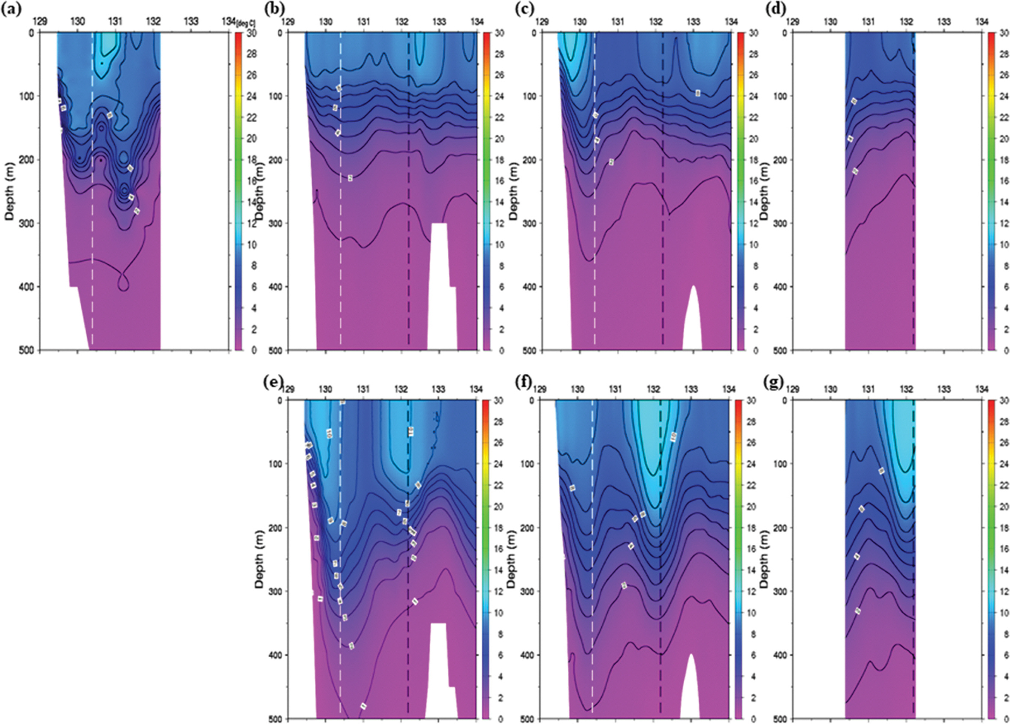
표층 유속 분포뿐 만 아니라 동해 상층의 수온 분포를 분석하기 위해, 국립수산과학원 정선관측자료 중 2월에 관측된 울릉도-독도 해역을 포함하는 정선관측 104 Line의 연직 수온단면도와 HYCOM, HY_UD1K, HY_UD300m, ES3K, ES_UD1K, ES_UD300m의 연직 수온단면도를 비교하였다(Fig. 9). 둥지격자기법의 최상위 모델인 HYCOM, ES3K 모델과 그 하위모델의 연직 수온분포가 각각 매우 유사하게 산출되었다. 관측자료와의 연직수온 분포 비교에서는 HYCOM을 둥지격자기법으로 적용한 HY_UD1K, HY_UD300m 모델의 모의결과가 정선관측자료와 조금 더 유사한 연직 수온 구조를 보이는 것을 확인할 수 있었다(Fig. 9a, 9c, 9d). Table 4는 UD300m 영역에 대해 정선관측 104라인의 2월 관측자료와 비교한 검증 결과이다. 우선 개방 경계자료인 HYCOM 자료는 관측에 비해 Mbias(-0.87)가 음수이며, HYCOM을 둥지격자기법으로 적용한 HY_UD1K(-1.70)와 HY_UD300m (-1.73)에서도 Mbias는 음수가 나타난다. 반대로 동해 3 km 수치모델은 양의 Mbias(0.16)가 나타나며, ES_UD1K(0.84)와 ES_UD300m(0.76) 또한 양의 Mbias가 나타난다. HYCOM과 동해 3 km 수치모델을 포함한 모든 수치모델 실험 결과에서 공간 상관계수(PCorr.)는 약 0.77 이상으로 99% 신뢰수준을 만족한다. 그러나 표층 약 12oC의 따뜻한 수괴 위치 및 깊이를 정확하게 모의하지 못하였으며, 과도하게 고수온의 수괴를 중층까지 깊게 모의하는 등의 문제를 확인하였다. 이러한 문제는 표층의 해수유동에 영향을 주는 것으로 확인되며, 실제로 HYCOM 둥지격자에서는 크게 나타나지 않는 표층 부분의 따뜻한 수괴가 ES3K 둥지격자기법 적용 모델들에서는 독도해역에 중층까지 깊게 모의하면서, 그 해역 주변에서 소용돌이가 매우 강하게 모의된 것으로 확인된다(Fig. 9e, 9f, 9g).
3.3 8월 평균 표층유속 비교
Mean Bias 및 RMSE가 증가하기 시작하는 8월에 대해서 CMEMS와 HYCOM, HY_UD1K, HY_UD300m, ES3K, ES_UD1K, ES_UD300m의 평균 유속을 비교하였다(Fig. 10). 울릉도-독도해역에서의 CMEMS에서 관측된 평균 유속은 약 19.38 cm/s이고, 울릉도 동쪽에서는 남하하는 흐름이, 독도 인근에서는 반시계방향으로 회전하는 소용돌이가 존재하였다(Fig. 10a). HYCOM 재분석자료의 모델 결과는 평균 유속이 17.26 cm/s로 CMEMS와 크게 차이나지 않으며, 전체적인 흐름도 매우 유사하게 산출되었다(Fig. 10b). 그러나 HYCOM을 둥지격자기법으로 적용하면서 HY_UD1K의 동한난류흐름이 울릉도 서쪽으로 들어오고, 그 중 일부가 울릉도 북쪽에서 사행하는 흐름으로 모의되었다. HY_UD1K의 평균 유속은 20.70 cm/s로 CMEMS의 평균유속과 거의 유사하게 산출되었으나, 울릉도 서쪽의 흐름이 CMEMS와 반대 방향으로 나타났고, 이는 HY_UD300m도 동일하게 나타났다(Fig. 10c, 10d). ES3K는 평균 유속이 약 14.57 cm/s로 약 5 cm/s 차이가 났으며, 북한한류 때문에 동한난류가 동쪽으로 치우쳐서 북상하는 것으로 모의하였다. 또한 독도 인근 해역에서의 소용돌이도 CMEMS 관측보다는 남쪽에 위치하는 것으로 나타났다(Fig. 10e). ES3K를 둥지격자기법에 적용한 ES_UD1K에서는 평균유속이 약 22.54 cm/s로 급격하게 증가하였으며, 동한난류가 ES3K보다 서쪽으로 치우쳐서 북상하는 것으로 모의하여 울릉도 서쪽에 북상하는 흐름이 크게 나타나지 않았고, 울릉도와 독도 사이에 반시계방향으로 회전하는 에디를 약하게 모의하는 것을 확인할 수 있었다. ES_UD300m는 평균 유속이 약 26.05 cm/s로 CMEMS보다는 약 7 cm/s, ES_UD1K 보다는 약 3.5 cm/s 크게 모의하였다. 비록 ES_UD300m는 ES_UD1K에서 모의하던 유속보다 매우 강하게 나타나지만, 울릉도 주변으로 남하하는 흐름과 울릉도와 독도 주변으로 반시계 방향의 소용돌이 흐름은 CMEMS 관측과 유사한 것으로 확인된다(Fig. 10f, 10g).
수산과학원 8월의 정선관측자료 중 정선관측 104 Line의 연직 수온단면도와 HYCOM, HY_UD1K, HY_UD300m, ES3K, ES_UD1K, ES_UD300m의 연직 수온 단면도를 비교하였다(Fig. 11). ES3K 모델은 수온 구배가 강하게 모의하는 경향이 나타나며, RMSE도 약 4.31°C로 다른 수치 실험에 비해 가장 높다(Table 5). 즉, 동일한 수심에서 수온의 변화가 크게 나타나는 경향 때문에 표층 유속이 크게 모의되는 것으로 판단된다(Fig. 11e). 그러나 ES_UD1K와 ES_UD300m는 동해 3 km 수치모델의 결과를 둥지 격자 기법으로 사용하였을 때, RMSE가 각각 약 2.48oC, 3.24°C로 수치 모델 결과가 많이 개선되었다. 특히 ES_UD1K와 ES_UD300m 수치실험에서 울릉도와 독도 사이 131.5oE 부근에서는 반시계방향의 소용돌이에 의해 나타나는 것은 등온선 수직 구조는 관측과 유사하다(Fig 10f, Fig 11f). HY_UD1K보다 중층의 찬 수괴가 상승한 연직 수온 분포가 매우 잘 나타났다(Fig. 11c, 11d).
HYCOM을 둥지격자 기법으로 실험한 HY_UD300m의 수온 수직 단면도를 관측된 수온분포와 비교했을 때, ES_UD300m와는 달리 1°C 등온선이 관측과 유사하게 수심 300~350 m 부근에 위치한다(Fig. 11a, 11d, 11g). 그러나 관측에서 131.5°E 부근에서 등온선 수직구조(마루 형태)가 관측과 같이 뚜렷하게 않으며 높게 나타난다. 따라서 HY_UD1K(HY_UD300m)의 RMSE는 약 2.52°C(약 3.01°C)로 ES_UD1K(ES_UD300m)와 유사하다(Table 5). 8월 104라인에 대한 수온 수직단면도의 공간 상관계수는 약 0.95 이상으로 상관계수가 높게 나타난다.
3.4 표층유속 월별 통계 검증 비교
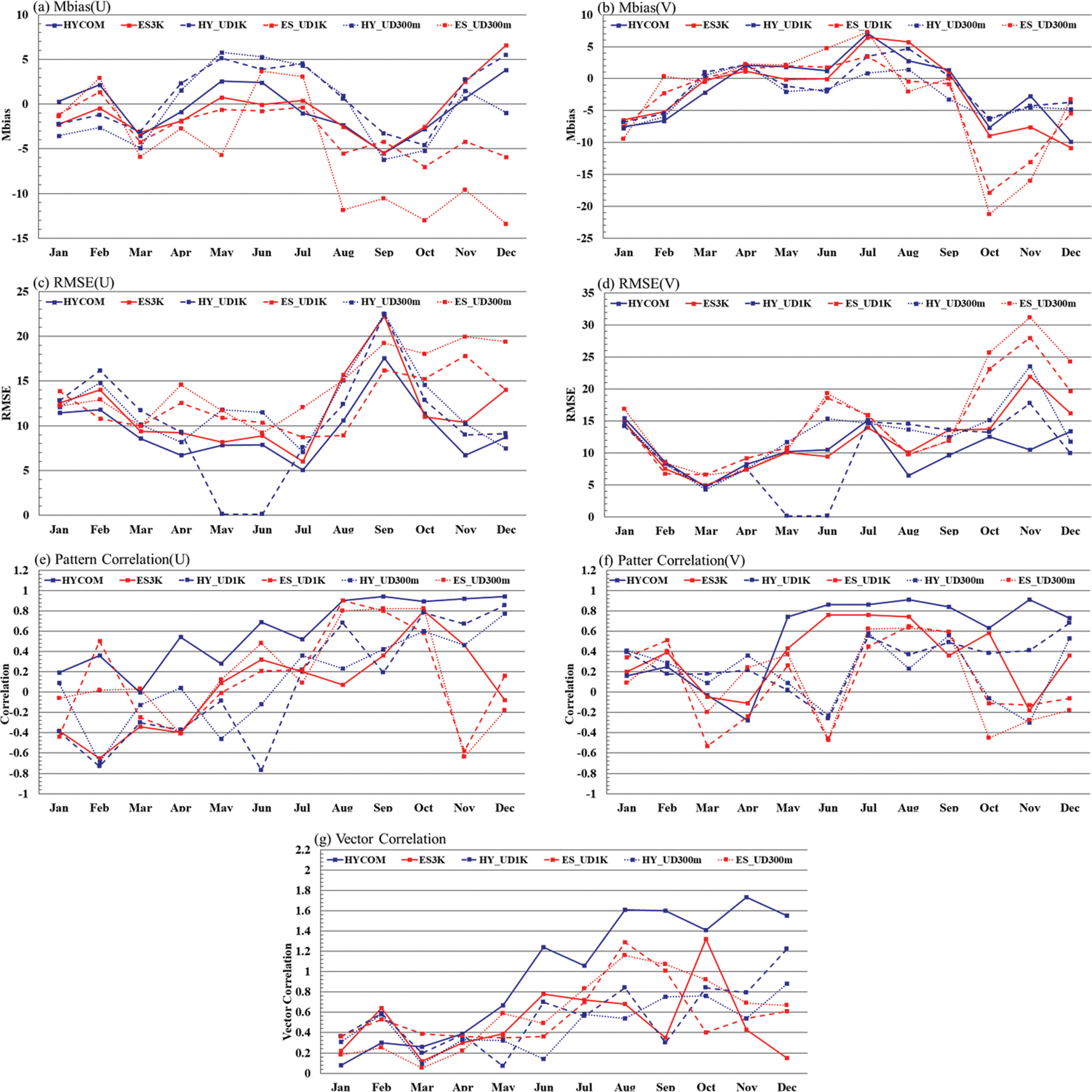
HYCOM 재분석자료, HY_UD1K, HY_UD1K를 경계자료로 한 HY_UD300m, 그리고 ES3K, ES_UD1K, ES_UD1K를 경계자료로 사용한 ES_UD300m의 표층유속 자료를 위성 관측자료(CMEMS)와 월별로 검증결과를 산출하였다(Fig. 12). HYCOM 둥지격자기법 적용 모델인 HY_UD1K, HY_UD300m의 모의 성능이 우수하게 나타났다. 1월~6월까지는 HYCOM 및 ES3K 둥지격자기법 적용 모델들의 모의 결과가 거의 유사한 Mbias, RMSE, Pattern Correlation(PCorr.)의 결과를 보이지만, 6월 이후부터는 HYCOM 둥지격자기법 적용 모델들의 모의 성능이 전반적으로 우수하게 산출되었다. ES3K 둥지격자기법 적용 모델들의 모의 결과에서 Mbias와 RMSE 오차가 동서 성분(u)은 8월~12월, 남북 성분(v)은 10월~12월 급격하게 증가하는 경향을 보였다. 이러한 패턴은 ES3K 둥지격자기법을 적용한 고해상도 모델(ES_UD1K, ES_UD300m)에서 두드러지게 나타났으며, 11월과 12월의 흐름은 CMEMS의 흐름과 반대되는 흐름(u, v 성분의 Pattern Correlation이 음수)이 우세하게 나타나는 것을 확인할 수 있었다. Vector Correlation에서는 HYCOM 재분석자료의 유속(u, v) 패턴이 가장 우수하게 산출되었으나, 나머지 모델의 결과는 거의 유사하게 나타났다(HYCOM: 약 0.99, ES3K: 약 0.51, HY_UD1K: 약 0.57, ES_UD1K: 약 0.58, HY_UD300m: 약 0.49, ES_UD300m: 약 0.59).
4. 결론 및 토의
본 연구에서는 ROMS 모델을 이용하여 울릉도-독도지역을 고해상도화하여 정확도 높은 결과를 산출하고자 HYCOM과 ES3K 모델 결과를 최상위 둥지격자로 설정하고, 단방향둥지격자 기법을 적용하여 UD1K를 거쳐 UD300m 모델을 수행하였다. 그 과정에서 상위모델과는 다른 수심 자료 및 내·외삽 방법에 의해 나타날 수 있는 개방 경계자료의 왜곡에 대한 보정방법을 제시하였다. 월별 모델 검증 결과를 비교해 보았을 때, 초고해상도 수치모델은 같은 조건임에도 불구하고 초기장 및 개방 경계자료에 따라 서로 다른 특징이 나타났다. HYCOM 자료를 사용한 단방향둥지격자기법 적용 모델(HY_UD1K, HY_UD300m)이 Mbias, RMSE, Pattern Correlation에서 ES3K를 사용한 단방향 둥지격자기법 적용 모델(ES_UD1K, ES_UD300m)들 보다 우수한 결과를 보였으나, Vector Correlation은 크게 차이를 보이지 않았다. 월 평균 유속 분포에서는 ES3K를 단방향 둥지격자기법으로 적용한 ES_ UD1K, ES_UD300m의 해수유동의 패턴이 CMEMS와 더 유사하게 산출되었고, 2월에는 ES_UD300m의 연직 수온분포가, 8월에는 HY_UD300m 연직 수온분포가 국립수산과학원의 연직 수온분포와 유사하게 산출되었다. ES3K를 단방향 둥지격자기법으로 적용한 모델들이 수온의 연직 경사를 강하게 모의하는 경향, 즉 같은 수심이라도 수온 변화가 크게 나타나는 특징이 있었으며, 그러한 영향 때문에 표층의 유속이 비교적 강하게 모의되는 현상을 확인할 수 있었다.
수평 해상도 1 km와 300 m 수치모델 실험을 비교했을 때에는 연평균자료에서 ES_UD300m의 동서 성분(u)의 PCorr. 만 0.12 정도 향상되었고, 나머지 검증 스코어에 대해서는 유사하거나 조금 더 안 좋은 결과를 보였으나, HY_UD300m은 HY_UD1K의 결과보다 RMSE와 Mbias, PCorr., VCorr. 모두 근소하게 향상되는 결과를 보였다. 그리고 Fig. 13과 같이 관측과 울릉도 1 km 수치모델(UD1K)에서 확인할 수 없었던 지형효과에 따른 카르만 와열(Karman vortex street)이 재현된 다거나 연직 수온 분포가 관측의 연직 수온분포와 유사하게 재현되는 특징을 보였다(Fig. 12d). 그러나 ES3K 모델보다는 수평 격자 간격이 100배, UD1K 모델보다는 10배 정도 향상된 해상도에 비해 정확도 검증 결과가 기대만큼 개선되지는 못하였다.
따라서 초고해상도 울릉도-독도의 수치모델(UD300m)을 개선을 위해서는 다양한 방면으로 고려할 필요가 있다. 먼저 본 연구에서 사용하였던 KPP 연직 스킴 이외에 Mellor-Yamada level 2.5와 같은 수직 혼합 모수화 기법을 도입하거나, ROMS 모델과는 다른 연직 Coordinate(z-Coordinate)를 가진 지역해 양수치모델(NEMO 또는 MOM)들을 동일한 해상도와 도메인에 대해 해양순환을 모의하여 비교해 볼 필요가 있다. 또한, 대기강제력(바람, 열속, 대기압 등)에서의 관측자료 및 고해상도의 재분석장 자료 등도 초고해상도 수치모델 구축에 있어 필요할 것으로 사료된다. 그리고 CMEMS 유속 자료는 약 25 km 수평해상도의 자료이기 때문에 300 m의 흐름을 상세하게 확인할 수 없다는 한계점이 있기 때문에, 고해상도의 관측자료도 검증을 위해 필요하다. 이외에도 개방 경계자료 및 초기장에 사용할 재분석 자료와 수평 점성항(Bi-harmonic, Smagorinsky scheme 등)에 대해서도 다양한 수치 실험을 할 필요가 있다.